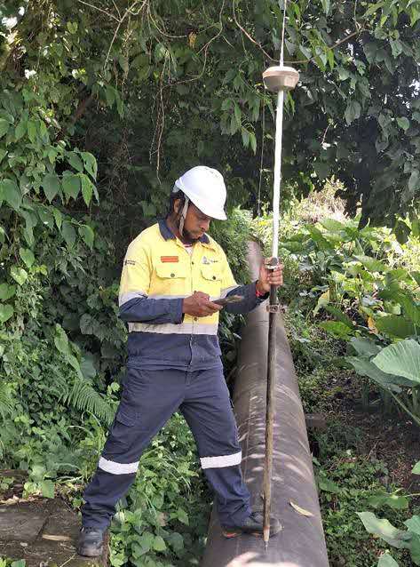
For Samson Enock, every coordinate recorded in the field tells a story. It is a story of precision, responsibility and progress but behind the sophisticated surveying equipment and digital terrain models stands a young Papua New Guinean whose journey began in the quiet village of Liorofa.
A member of the Giyamato Clan, Enock started his formal education in 2009, completing his primary education between 2009 and 2016 before progressing through secondary school from 2017 to 2020. Driven by determination and a passion for technical studies, he continued his education at the University of Technology (UOT), graduating in 2024 with the qualifications needed to pursue a career in mine surveying.
Like many fresh graduates, Enock eagerly anticipated his first opportunity to enter the workforce. That opportunity arrived in 2025 when he received the call to join Ramu NiCo Management (MCC) Limited’s Graduate Development Scheme (GDS).
“As a fresh graduate, I was grateful for the opportunity and immediately saw it as a chance to gain practical experience, develop my skills, and start building my career in the mining industry,” Enock recalled.
Today, Enock serves as a Graduate Surveyor attached to the Survey and Technical Planning Section within Mine Technical Services (MTS), where he has spent the past six months gaining invaluable hands-on experience in one of Papua New Guinea’s largest mining operations.
While mining is often associated with heavy machinery and excavation, Enock says surveying forms the backbone of every successful operation.
The Survey Section is responsible for collecting accurate field data and converting it into precise coordinates, maps and three-dimensional models that guide mining activities.
These datasets support mine planning, geological modelling, engineering designs, infrastructure development, land acquisition, production reporting and statutory reporting to the Mineral Resources Authority (MRA).
Survey information also plays a critical role in maintaining operational efficiency, ensuring safety standards and supporting informed decision-making throughout the mine’s life cycle.
Working across the Kurumbukari Mine Site and supporting operations connected to the Basamuk Processing Plant via the integrated slurry pipeline, Enock has gained practical exposure to several specialised surveying disciplines.
One of his major responsibilities has involved conducting Digital Terrain Model (DTM) surveys, where he captures changes in mine topography after excavation. Using high-precision Real Time Kinematic (RTK) Global Navigation Satellite System (GNSS) equipment, Enock collects accurate field data before processing it in Surpac software to generate three-dimensional terrain models using Triangulated Irregular Networks (TIN).
These models enable engineers and planners to accurately calculate the volume of material mined or remaining, providing essential information for production reconciliation and mine planning.
He has also participated in stockpile surveys, where survey data is collected across ore, waste rock and chromite stockpiles. By generating accurate surface models and comparing them against base surfaces, the Survey Section determines stockpile volumes that support inventory reconciliation and production reporting.
Another important area of Enock ‘s attachment has been Clan Land and Boundary Tracking within Special Mining Lease 8 (SML 8).
This work involves cross-referencing month-end pit surveys with digital clan boundary data to produce accurate land clearance audits. The information assists the Legal and Community Affairs teams in ensuring transparent and accurate royalty payments to customary landowners.
“It reinforced the importance of accuracy because survey data doesn’t only support mining operations—it also contributes to fair and transparent royalty payments for local communities,” Enock explained.
Beyond the mine pit, Enock has also assisted with surveys along the slurry pipeline connecting Kurumbukari Mine to the Basamuk Processing Plant.
Using RTK GNSS technology, he verifies the pipeline’s horizontal alignment and vertical levels while monitoring any positional movement or settlement. The centimetre-level accuracy achieved through these surveys helps ensure the pipeline continues operating safely and according to engineering design specifications.
Reflecting on his Graduate Development Scheme attachment, Enock says the experience has transformed the theoretical knowledge gained at university into practical professional skills.
He has strengthened his confidence in RTK GNSS setup, survey control verification and field data collection while becoming proficient in generating and analysing TIN surfaces using Surpac software. He has also developed a deeper understanding of coordinate systems, spatial referencing and cut and fill volume computations used in production reporting.
Beyond the technical aspects, Enock has gained a broader appreciation of how survey data influences mining operations.
“I’ve learned how production reconciliation depends on accurate survey information, how centimetre-level precision impacts operational decisions, and how survey calculations directly influence production accountability and financial reporting,” Enock said.
Looking back over the past six months, Enock believes the Graduate Development Scheme has provided the ideal platform to launch his professional career.
The attachment has equipped him with practical field experience, strengthened his technical capabilities and instilled greater confidence in handling real operational responsibilities.
More importantly, it has demonstrated the vital contribution mine surveyors make to safe, efficient and accountable mining operations.
As he continues developing his career with Ramu NiCo Management (MCC) Limited, Samson remains committed to continuous learning and professional growth.
From the classrooms of Liorofa to the high-precision survey instruments guiding one of Papua New Guinea’s largest mining operations, his journey reflects the purpose of the Graduate Development Scheme developing capable young professionals who are ready to help shape the future of the country’s mining industry.
For Samson Enock, every coordinate mapped today is another step toward a promising future.